Geiranger
| Geiranger | |
|---|---|
Village | |
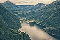
 Geiranger and Geirangerfjord from Flydalsjuvet | |
 Geiranger Location in Møre og Romsdal Show map of Møre og Romsdal  Geiranger Geiranger (Norway) Show map of Norway | |
Coordinates: 62°05′58″N 07°12′23″E / 62.09944°N 7.20639°E / 62.09944; 7.20639Coordinates: 62°05′58″N 07°12′23″E / 62.09944°N 7.20639°E / 62.09944; 7.20639 | |
| Country | Norway |
| Region | Western Norway |
| County | Møre og Romsdal |
| District | Sunnmøre |
| Municipality | Stranda Municipality |
| Elevation[1] | 40 m (130 ft) |
| Population | |
| • Total | 250 |
| Time zone | CET (UTC+01:00) |
| • Summer (DST) | CEST (UTC+02:00) |
| Post Code | 6216 Geiranger |
Geiranger is a small tourist village in Sunnmøre region of Møre og Romsdal county in the western part of Norway. It lies in Stranda at the head of the Geirangerfjorden, which is a branch of the large Storfjorden. The nearest city is Ålesund. Geiranger is home to some of the most spectacular scenery in the world, and has been named the best travel destination in Scandinavia by Lonely Planet. Since 2005, the Geirangerfjord area has been listed as a UNESCO World Heritage Site. The Seven Sisters waterfall is located just west of Geiranger, directly across another waterfall called "The Suitor."[2][3]Norwegian County Road 63 passes through the village. Geiranger Church is the main church for the village and surrounding area.
Geiranger is under constant threat from the mountain Åkerneset which could erode into the fjord. A collapse could cause a tsunami that could destroy downtown Geiranger.
Contents
1 The name
2 Tourism
3 Media gallery
4 In popular culture
5 References
6 External links
The name
The Norse form of the name was Geirangr. The suffix -angr ('fjord') - a common element in Norwegian place names (see for instance Hardanger and Varanger).[4][5] The first element could be the plural genitive of the Norse word geiri ('piece of land; field in a mountain side') - which is related to English gore ('spearshaped piece of land'). This would then refer to the several small farms and fields lying in the steep mountain sides around the fjord. (See Knivsflå and Skageflå.)
Tourism
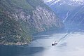
This third biggest cruise ship port in Norway receives 140 to 180 ships during the four-month tourist season. In 2012 some 300,000 cruise passengers visited Geiranger during the summer season.[6] The Geiranger Port has a cruise terminal, a Seawalk, and 3–4 anchor positions depending on the size of the ships. Constructed in 2013, the Seawalk is a three-segment articulated floating pier, 236 m long and 4.5 m wide on 10 pontoons, which moves (like a floatable jetwalk) to accommodate up to 4,000 passengers per hour disembarking from a single ship.[7]
Several hundred thousand people pass through every summer, and tourism is the main business for the 250 people who live there permanently. There are five hotels and over ten camping sites. The tourist season stretches from May to early September. Tours of the nearby historic farms of Knivsflå and Skageflå are available from Geiranger.
Each year in June, the Geiranger – From Fjord to Summit event occurs. It comprises a half marathon run and a bicycle race, both starting from the sea level at the fjord and ending at the 1,497 metres (4,911 ft) summit of Mount Dalsnibba, near the lake Djupvatnet. Since there is still a lot of snow left in the mountains at that time of year, the race is also called "From Summer to Winter".
Media gallery

The seven sisters waterfall over Geirangerfjord

View of the village of Geiranger

Geiranger Church

Cruise ship at Geiranger
View of Geiranger

View of the Geirangerfjord
The coastal express passes the old fjord farm Lundaneset

Chair at Flydalsjuvet
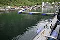
Geiranger movable Seawalk on pontoons


In popular culture
- Released in March 2016, "The Wave (Bølgen)" is a Norwegian disaster movie based on the premise of a rock slide from the mountain Åkerneset inundating the town of Geiranger.[8]
References
^ "Geiranger" (in Norwegian). yr.no. Retrieved 2010-10-10.
^ Store norske leksikon. "Geiranger" (in Norwegian). Retrieved 2010-10-10.
^ Placeaholic. "20 Things To Do And Best Places to Take Photos In Norway". Retrieved 2016-05-18.
^ Rygh, O. (1896). Norske Fjordnavne. Kristiania: Aschehoug.
^ Helle, Knut (1975). Stavanger: fra våg til by. Stavanger: Stabenfeldt. ISBN 8253201893.
^ Dagens Næringsliv. 12 October 2012, p.26.
^ "Geiranger Port and Hellesylt Port". stranda-hamnevesen.no. Retrieved 27 July 2017.
^ "The Wave (2015) Bølgen (original title)". IMDb. Retrieved 16 March 2016.
External links
| Wikimedia Commons has media related to Geiranger. |
| Wikivoyage has a travel guide for Geiranger. |
 Geiranger travel guide from Wikivoyage
- geiranger.no
- Destinasjon Geirangerfjord - Trollstigen
- Image from Geiranger
- Geiranger - From Fjord to Summit
- UNESCO World Heritage
- Geiranger in 360 degrees VR panorama
Authority control |
|
|---|

 Clash Royale CLAN TAG#URR8PPP
