Aare
| Aare | |
|---|---|
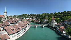 The Aare at Bern | |
 Drainage basin of the Aare | |
| Country | Switzerland |
| Cantons | Bern, Solothurn, Aargau |
| Settlements | Meiringen (BE), Interlaken (BE), Thun (BE), Münsingen, Muri bei Bern, Bern, Bremgarten bei Bern, Aarberg (BE), Büren a.A. (BE), Solothurn (SO), Aarwangen (BE), Aarburg (BE), Olten (SO), Niedergösgen (SO), Schönenwerd (SO), Aarau (AG), Wildegg (AG), Brugg (AG), Windisch (AG), Döttingen (AG), Klingnau (AG) |
| Physical characteristics | |
| Main source | Unteraar Glacier, Bernese Highlands 1,940 m (6,360 ft) 46°33′48″N 8°25′57″E / 46.56341°N 8.43259°E / 46.56341; 8.43259 |
| River mouth | Rhine below Koblenz, Switzerland 311 m (1,020 ft) 47°36′21″N 8°13′24″E / 47.6057°N 8.2234°E / 47.6057; 8.2234Coordinates: 47°36′21″N 8°13′24″E / 47.6057°N 8.2234°E / 47.6057; 8.2234 |
| Length | 291.5 kilometres (181.1 mi) [1] |
| Discharge |
|
| Basin features | |
| Progression | Rhine→ North Sea |
| Basin size | 17,779 km2 (6,865 sq mi) |
| Tributaries |
|
| Waterbodies | Oberaarsee, Grimselsee, Räterichsbodensee, Lake Brienz, Lake Thun, Wohlensee, Lake Biel, Stausee Niederried, Klingnauer Stausee |
The Aare (German pronunciation: [ˈaːrə]) or Aar is a tributary of the High Rhine and the longest river that both rises and ends entirely within Switzerland.[2][3]
Its total length from its source to its junction with the Rhine comprises about 295 kilometres (183 mi),[2][4] during which distance it descends 1,565 m (5,135 ft), draining an area of 17,779 km2 (6,865 sq mi), almost entirely within Switzerland, and accounting for close to half the area of the country, including all of Central Switzerland.[4]
There are more than 40 hydroelectric plants along the course of the Aare River.[5]
The river's name dates to at least the La Tène period, and it is attested as Nantaror "Aare valley" in the Berne zinc tablet.
The name was Latinized as Arula/Arola/Araris.[6][nb 1]
Contents
1 Course
2 Tributaries
3 Reservoirs
4 Notes
5 Footnotes
6 References
7 External links
Course
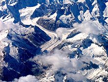
The Unteraargletscher

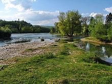
The Aare at Innertkirchen

Inside the Aare Gorge
The Aare rises in the great Aargletschers (Aare Glaciers) of the Bernese Alps, in the canton of Bern and west of the Grimsel Pass.[2] The Finsteraargletscher and Lauteraargletscher come together to form the Unteraargletscher (Lower Aar Glacier), which is the main source of water for the Grimselsee (Lake of Grimsel).[3][5] The Oberaargletscher (Upper Aar Glacier) feeds the Oberaarsee, which also flows into the Grimselsee.[3] The Aare leaves the Grimselsee just to the east to the Grimsel Hospiz, below the Grimsel Pass, and then flows northwest through the Haslital, forming on the way the magnificent Handegg Waterfall, 46 m (151 ft), past Guttannen.
Right after Innertkirchen it is joined by its first major tributary, the Gamderwasser. Less than 1 kilometre (0.62 mi) later the river carves through a limestone ridge in the Aare Gorge (German: Aareschlucht).[2] It is here that the Aare proves itself to be more than just a river, as it attracts thousands of tourists annually to the causeways through the gorge.[3] A little past Meiringen, near Brienz, the river expands into Lake Brienz. Near the west end of the lake it indirectly receives its first important tributary, the Lütschine, by the Lake of Brienz. It then runs across the swampy plain of the Bödeli (Swiss German diminutive for ground) between Interlaken and Unterseen before flowing into Lake Thun.[2]
Near the west end of Lake Thun, the river indirectly receives the waters of the Kander, which has just been joined by the Simme, by the Lake of Thun. Lake Thun marks the head of navigation.[5] On flowing out of the lake it passes through Thun, and then flows through the city of Bern, passing beneath eighteen bridges and around the steeply-flanked peninsula on which the Old City of Berne is located. The river soon changes its northwesterly flow for a due westerly direction, but after receiving the Saane or La Sarine it turns north until it nears Aarberg. There, in one of the major Swiss engineering feats of the 19th century, the Jura water correction, the river, which had previously rendered the countryside north of Bern a swampland through frequent flooding, was diverted by the Aare-Hagneck Canal into the Lac de Bienne. From the upper end of the lake, at Nidau, the river issues through the Nidau-Büren Canal, also called the Aare Canal,[3] and then runs east to Büren. The lake absorbs huge amounts of eroded gravel and snowmelt that the river brings from the Alps, and the former swamps have become fruitful plains: they are known as the "vegetable garden of Switzerland".
From here the Aare flows northeast for a long distance, past the ambassador town Solothurn[2] (below which the Grosse Emme flows in on the right), Aarburg (where it is joined by the Wigger), Olten, Aarau,[2] near which is the junction with the Suhre, and Wildegg, where the Seetal Aabach falls in on the right. A short distance further, below Brugg it receives first the Reuss, its major tributary, and shortly afterwards the Limmat, its second strongest tributary. It now turns to north, and soon becomes itself a tributary of the Rhine, which it even surpasses in volume when the two rivers unite downstream from Koblenz (Switzerland), opposite Waldshut in Germany. The Rhine, in turn, empties into the North Sea after crossing into the Netherlands.
Tributaries
At the "Wasserschloss", where the rivers Aare, Reuss and Limmat flow together

Aare in Bern

The convergence of the Aare and the Rhine at Koblenz
Limmat (after and northeast of Brugg, and northwest of Baden)- Reppisch
Sihl- Alp
- Minster
Lake Zurich
Linthkanal
Lake Walen
Linth- Löntsch
- Sernf
- Flätschbach
- Seez
Reuss (after and northeast of Brugg, and northwest of Baden)- Lorze
- Kleine Emme
Lake Lucerne- Sarner Aa
- Engelberger Aa
- Muota
- Schächen
- Chärstelenbach
- Göschener Reuss
Aabach (coming from Seetal, in Wildegg)- Bünz
Suhre (after and north of Aarau)- Wyna
- Aabach (from the left in Aarau)
- Stegbach
Dünnern (in Olten)
Wigger (right before Aarburg)
Murg (before, west of Murgenthal)- Rot (Roggwil)
- Langete (Langenthal)
- Ursenbach (Kleindietwil)
- Rotbach (Huttwil)
(Grosse) Emme (after, east of Solothurn)
Lake of Bienne
La Suze (in Biel/Bienne, right next to the outflow)
Zihlkanal
Lake of Neuchatel
La Broye (flows through Lake Morat)
Zihl/La Thielle- L'Orbe
- Le Talent
Saane/La Sarine (after, west of Wohlensee)- Sense
Gürbe (in Muri bei Bern)
Zulg (west of Steffisburg)
Lake Thun
Kander (west of Spiez)- Simme
- Entschlige
Lake Brienz
Lütschine (at the end of Lake Brienz, right next to the outflow)
Gadmerwasser (right after, northwest of Innertkirchen)
Reservoirs
Lake Grimsel,[8] 1,908 metres (6,260 ft)
Lake Brienz,[8] 564 metres (1,850 ft)[9]
Lake Thun,[8] 558 metres (1,831 ft)[9]
Lake Wohlen,[10] 481 metres (1,578 ft)
Niederriedsee,[10] 461 metres (1,512 ft)
Lake Biel,[10] 429 metres (1,407 ft)
Klingnauer Stausee, 318 metres (1,043 ft)
Notes
^ The river Obringa, mentioned by Ptolemy (2.7.9) as a tributary of the Rhine, has been identified with either the Mosel or the Aare.[7]
Footnotes
^ Geoserver of the Swiss Confederation
^ abcdefg Bridgwater & Aldrich 1968, p. 11
^ abcde Gresswell & Huxley 1965, p. 27
^ ab Hoiberg 2010, p. 4
^ abc Cohen 1998, p. 1
^ Kristol et al. 2005, p. 73
^ Forbiger 1848, p. 126f
^ abc Anon 1973, p. 74
^ ab Gresswell & Huxley 1965, p. 272
^ abc Anon 1973, p. 70
References
Anon (1973). Atlas Routier et Touristique (in French). Paris, France: Bordas-Tirade.
Bridgwater, W.; Aldrich, Beatrice, eds. (1968). "Aare". The Columbia-Viking Desk Encyclopedia (3rd ed.). New York, NY: Columbia University Press. ISBN 978-0670230709.
Cohen, Saul B., ed. (1998). "Aare". The Columbia Gazetteer of the World. New York, NY: Columbia University Press. ISBN 0-231-11040-5.
Forbiger, Albert (1848). Handbuch Der Alten Geographie. 3. Leipzig, Germany: Veriag von Gustav Mayer.
Gresswell, R. Kay; Huxley, Anthony, eds. (1965). Standard Encyclopedia of the World's Rivers and Lakes. New York, NY: G. P. Putnam's Sons.
Hoiberg, Dale H., ed. (2010). "Aare River". Encyclopædia Britannica (15th ed.). Chicago, IL: Encyclopædia Britannica, Inc. ISBN 0-85229-961-3.
Kristol, Andres; Cattin, Florence; Meroni, Barbara; Schmid, Gabrielle, eds. (2005). "Aarau AG (Aarau)" [Encyclopedia of the Swiss municipality of LSG: Dictionnaire de toponymique scommunes Suisses DTS / Dizionario dei comuni toponomastico svizzeri DTS]. Lexikon der schweizerischen Gemeindenamen LSG: Dictionnaire toponymique de scommunes suisses DTS /Dizionario toponomastico dei comuni svizzeri DTS (in German) (1st ed.). Stuttgart, Germany: Huber Frauenfeld. ISBN 3-7193-1308-5.
External links
| Wikimedia Commons has media related to Aare. |
- The Aare Gorge (Aareschlucht)
 Texts on Wikisource:
"Aar". The Nuttall Encyclopædia. 1907.
"Aar". Encyclopædia Britannica (11th ed.). 1911.
"Aar". Collier's New Encyclopedia. 1921.
Tributaries of the Rhine | ||
|---|---|---|
| Left (western) |
|  |
| Right (eastern) |
| |
Authority control |
|
|---|

 Clash Royale CLAN TAG#URR8PPP
