Ida County, Iowa
Ida County, Iowa | |
|---|---|
 Ida County Courthouse | |
 Location in the U.S. state of Iowa | |
 Iowa's location in the U.S. | |
| Founded | 15 January 1851 |
| Seat | Ida Grove |
| Largest city | Ida Grove |
| Area | |
| • Total | 432 sq mi (1,119 km2) |
| • Land | 432 sq mi (1,119 km2) |
| • Water | 0.5 sq mi (1 km2), 0.1% |
| Population | |
| • (2010) | 7,089 |
| • Density | 16/sq mi (6/km2) |
| Congressional district | 4th |
| Time zone | Central: UTC−6/−5 |
| Website | www.idacounty.org/default.asp |
Ida County is a county located in the U.S. state of Iowa. As of the 2010 census, the population was 7,089.[1] The county seat is Ida Grove.[2] The county was formed on January 15, 1851. It was probably named after Ida Smith, the first child of European immigrants to be born in this region.[citation needed]
Contents
1 Geography
1.1 Major highways
1.2 Adjacent counties
2 Demographics
2.1 2010 census
2.2 2000 census
3 Communities
3.1 Cities
3.2 Unincorporated communities
3.3 Townships
3.4 Population ranking
4 Politics
5 See also
6 References
7 External links
Geography
According to the U.S. Census Bureau, the county has a total area of 432 square miles (1,120 km2), of which 432 square miles (1,120 km2) is land and 0.5 square miles (1.3 km2) (0.1%) is water.[3]
Major highways
 U.S. Highway 20
 U.S. Highway 59
 Iowa Highway 31
 Iowa Highway 175
Adjacent counties
Cherokee County (north)
Sac County (east)
Crawford County (south)
Woodbury County (west)
Demographics
| Historical population | |||
|---|---|---|---|
| Census | Pop. | %± | |
| 1860 | 43 | — | |
| 1870 | 226 | 425.6% | |
| 1880 | 4,382 | 1,838.9% | |
| 1890 | 10,705 | 144.3% | |
| 1900 | 12,327 | 15.2% | |
| 1910 | 11,296 | −8.4% | |
| 1920 | 11,689 | 3.5% | |
| 1930 | 11,933 | 2.1% | |
| 1940 | 11,047 | −7.4% | |
| 1950 | 10,697 | −3.2% | |
| 1960 | 10,269 | −4.0% | |
| 1970 | 9,283 | −9.6% | |
| 1980 | 8,908 | −4.0% | |
| 1990 | 8,365 | −6.1% | |
| 2000 | 7,837 | −6.3% | |
| 2010 | 7,089 | −9.5% | |
| Est. 2016 | 6,985 | [4] | −1.5% |
| U.S. Decennial Census[5] 1790-1960[6] 1900-1990[7] 1990-2000[8] 2010-2013[1] | |||
2010 census
The 2010 census recorded a population of 7,089 in the county, with a population density of 16.4207/sq mi (6.3401/km2). There were 3,426 housing units, of which 3,052 were occupied.[9]
2000 census
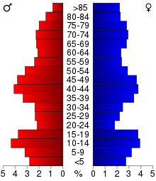
2000 Census Age Pyramid for Ida County
As of the census[10] of 2000, there were 7,837 people, 3,213 households, and 2,184 families residing in the county. The population density was 18 people per square mile (7/km²). There were 3,506 housing units at an average density of 8 per square mile (3/km²). The racial makeup of the county was 99.02% White, 0.10% Black or African American, 0.06% Native American, 0.24% Asian, 0.15% from other races, and 0.42% from two or more races. 0.47% of the population were Hispanic or Latino of any race.
There were 3,213 households out of which 29.40% had children under the age of 18 living with them, 59.50% were married couples living together, 5.90% had a female householder with no husband present, and 32.00% were non-families. 29.30% of all households were made up of individuals and 15.90% had someone living alone who was 65 years of age or older. The average household size was 2.39 and the average family size was 2.95.
In the county, the population was spread out with 25.50% under the age of 18, 6.10% from 18 to 24, 24.00% from 25 to 44, 22.70% from 45 to 64, and 21.80% who were 65 years of age or older. The median age was 42 years. For every 100 females there were 93.90 males. For every 100 females age 18 and over, there were 91.40 males.
The median income for a household in the county was $34,805, and the median income for a family was $43,179. Males had a median income of $29,002 versus $19,417 for females. The per capita income for the county was $18,675. About 5.70% of families and 8.80% of the population were below the poverty line, including 9.10% of those under age 18 and 8.60% of those age 65 or over.
Communities
Cities
- Arthur
- Battle Creek
- Galva
- Holstein
- Ida Grove
Unincorporated communities
Townships
- Battle
- Blaine
- Corwin
- Douglas
- Galva
- Garfield
- Grant
- Griggs
- Hayes
- Logan
- Maple
- Silver Creek
Population ranking
The population ranking of the following table is based on the 2010 census of Ida County.[11]
† county seat
| Rank | City/Town/etc. | Municipal type | Population (2010 Census) |
|---|---|---|---|
| 1 | † Ida Grove | City | 2,142 |
| 2 | Holstein | City | 1,396 |
| 3 | Battle Creek | City | 713 |
| 4 | Galva | City | 434 |
| 5 | Arthur | City | 206 |
Politics
| Year | Republican | Democratic | Third Parties |
|---|---|---|---|
2016 | 73.5% 2,655 | 21.9% 792 | 4.6% 165 |
2012 | 62.4% 2,286 | 36.1% 1,321 | 1.5% 56 |
2008 | 57.4% 2,036 | 41.0% 1,454 | 1.6% 57 |
2004 | 62.1% 2,342 | 37.5% 1,415 | 0.5% 17 |
2000 | 56.4% 1,968 | 40.4% 1,411 | 3.2% 112 |
1996 | 45.1% 1,684 | 42.6% 1,589 | 12.3% 459 |
1992 | 40.4% 1,714 | 34.2% 1,449 | 25.4% 1,076 |
1988 | 51.6% 1,951 | 47.3% 1,787 | 1.1% 41 |
1984 | 62.3% 2,618 | 37.1% 1,559 | 0.6% 25 |
1980 | 64.9% 2,825 | 28.4% 1,235 | 6.8% 294 |
1976 | 56.9% 2,590 | 41.0% 1,868 | 2.1% 97 |
1972 | 64.7% 2,819 | 34.2% 1,490 | 1.2% 50 |
1968 | 62.2% 2,753 | 33.1% 1,463 | 4.7% 209 |
1964 | 40.5% 1,977 | 59.5% 2,905 | 0.0% 2 |
1960 | 62.8% 3,290 | 37.2% 1,949 | 0.0% 2 |
1956 | 60.8% 3,226 | 39.2% 2,083 | 0.0% 1 |
1952 | 70.1% 3,800 | 29.6% 1,603 | 0.3% 15 |
1948 | 48.0% 2,257 | 50.3% 2,365 | 1.6% 76 |
1944 | 57.4% 2,640 | 42.2% 1,943 | 0.4% 18 |
1940 | 57.7% 3,166 | 42.0% 2,306 | 0.3% 15 |
1936 | 34.4% 1,834 | 63.7% 3,397 | 1.9% 102 |
1932 | 28.0% 1,452 | 70.6% 3,661 | 1.4% 74 |
1928 | 52.8% 2,486 | 46.1% 2,172 | 1.1% 53 |
1924 | 43.5% 2,033 | 14.6% 685 | 41.9% 1,960 |
1920 | 75.7% 3,547 | 23.3% 1,090 | 1.0% 47 |
1916 | 51.1% 1,412 | 45.0% 1,244 | 3.8% 106 |
1912 | 19.0% 530 | 38.9% 1,087 | 42.1% 1,175 |
1908 | 53.0% 1,367 | 45.8% 1,181 | 1.2% 32 |
1904 | 60.7% 1,565 | 36.4% 940 | 2.9% 75 |
1900 | 54.2% 1,599 | 44.2% 1,304 | 1.6% 46 |
1896 | 50.4% 1,475 | 48.5% 1,421 | 1.1% 33 |
See also
- Ida County Courthouse
- National Register of Historic Places listings in Ida County, Iowa
Waveland Round Barn, listed on the National Register of Historic Places
References
^ ab "State & County QuickFacts". United States Census Bureau. Archived from the original on 11 July 2011. Retrieved 17 July 2014.
^ "Find a County". National Association of Counties. Archived from the original on 31 May 2011. Retrieved 7 June 2011.
^ "US Gazetteer files: 2010, 2000, and 1990". United States Census Bureau. 12 February 2011. Retrieved 23 April 2011.
^ "Population and Housing Unit Estimates". Retrieved 9 June 2017.
^ "U.S. Decennial Census". United States Census Bureau. Archived from the original on 12 May 2015. Retrieved 17 July 2014.
^ "Historical Census Browser". University of Virginia Library. Retrieved 17 July 2014.
^ "Population of Counties by Decennial Census: 1900 to 1990". United States Census Bureau. Retrieved 17 July 2014.
^ "Census 2000 PHC-T-4. Ranking Tables for Counties: 1990 and 2000" (PDF). United States Census Bureau. Retrieved 17 July 2014.
^ "Population & Housing Occupancy Status 2010". United States Census Bureau – American FactFinder. Retrieved 18 May 2011.
^ "American FactFinder". United States Census Bureau. Retrieved 31 January 2008.
^ "Archived copy". Archived from the original on 21 December 2013. Retrieved 13 February 2016.
^ Leip, David. "Dave Leip's Atlas of U.S. Presidential Elections". uselectionatlas.org. Retrieved 26 April 2018.
External links
| Wikimedia Commons has media related to Ida County, Iowa. |
- Ida County Economic Development
- Ida County Sheriff
Places adjacent to Ida County, Iowa | ||||||||||
|---|---|---|---|---|---|---|---|---|---|---|
| ||||||||||
Municipalities and communities of Ida County, Iowa, United States | ||
|---|---|---|
County seat: Ida Grove | ||
| Cities |
| |
Des Moines (capital) | ||
| Topics |
|  |
| Regions |
| |
| Largest cities |
| |
| Counties |
| |
Coordinates: 42°23′12″N 95°30′52″W / 42.38667°N 95.51444°W / 42.38667; -95.51444

 Clash Royale CLAN TAG#URR8PPP
